Mount Takao - Tokyo's Local Mountain
- Paolo Decena

- Jan 14, 2020
- 6 min read
Updated: Jan 14, 2020
Mount Takao is one of the more famous nature spots in Tokyo prefecture, located in Hachioji, which is the western part of the prefecture. Popular for tourists and locals alike, the landmark draws a large crowd all year round, such that there are barbecue areas, dango stalls, and other attractions dotted along the way up. There are many ways to go up to the peak, with a combination of eight trails and two transportation methods available. What this all boils down to is that there are a lot of people going up and down the mountain.

We chose to go up Mount Takao in autumn, not too long after a typhoon hit the area. As a consequence there were some trails that were closed off from the public. I had wanted to go up the longest trail, in part because I was more interested in seeing nature and not the tourist attractions, but it was one of the closed trails. We settled on going up trail one, the easiest and most touristy trail.

Having lived in the Metro Vancouver area of Canada, there was a point where I would go up our own touristy hike of the Grouse Grind every weekend. My best time going up the three-kilometre trail was just under an hour, and I heard beforehand that trail one was about four kilometres. I expected to tackle the mountain in the same fashion as the Grind: using a slow, methodical pace and take no breaks. It turned out that I greatly overestimated Mount Takao's trail one.
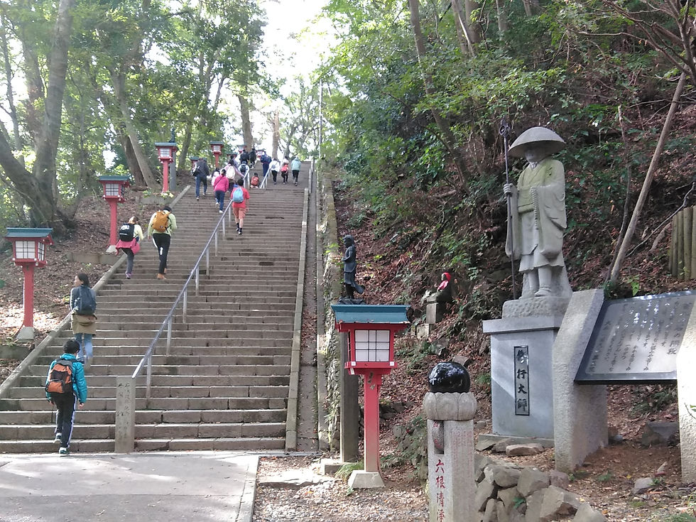
Trail one, from the foot of the mountain to the top, was more or less a concrete road. As we ascended, there were points where vehicles would actually drive past us. I remember in particular a small, white flat-bed truck that zoomed up the trail. Inside looked to be the maintenance workers of the trails. The driver of the vehicle looked as if he had gone up and down this same trail hundreds of times, navigating the trail's hairpin turns with practiced speed and precision, minding the dozens of hikers going up the trail.

There were probably more than dozens of hikers when we went up trail one. Most past us as I insisted we would catch up to them. I recounted my anecdotes of when my friends and I would look down on those that would try to climb the Grind at a pace that was too quick for them, resulting in them taking a break that was far too long for their own good, and we would ultimately reach the top long before them. There was a pair of women in their twenties that passed us at a pace only slightly faster than my girlfriend and I. I mentally criticised them, thinking that they would get tired at some point and then we would pass them when they were taking a break.
We followed them up the trail, and at some point we reached the area where the lift and cable car stations dropped off the people that didn't want to bother with the first half of the mountain. The slop tapered off around this area, becoming almost flat, so the going was very easy. Continuing along, we passed by several tourist attractions, including the monkey park, a temple, and barbecue areas. Neither of us were particularly interested in the monkey park. with me thinking it would just be a troop of monkeys in a small enclosure, but the temple was obligatory: the trail passed right through the temple grounds.

Yakuoin Temple was multiple levels, or at least it seemed so. There were a couple flights of stairs going up to other buildings. I'm not particularly sure if the buildings were part of the same complex, but they looked as if they had religious purposes. All three levels had the fire pots that produced some cleansing smoke. This smoke is wafted by visitors over their heads to bless themselves. The first level of the area was the largest, and there were some unique features I've never seen before. In particular, the first level had a giant stone prayer wheel, and I watched as a diminutive Japanese lady did her best to turn the wheel. There were a fair amount of people around this area, all praying or browsing the wares that were being sold here.

Continuing past the temple buildings and the shops that were part of it, there was another stretch of hiking before there was a fork in the road. On our left was a set of concrete stairs labelled in Japanese 'otoko-zaka' or 'the man's trail', and on our right was a meandering pathway with a gentle incline labelled 'onna-zaka' or 'the woman's trail." The labelling was apparently a common practice in hikes across Japan, and it was a point of bother for my girlfriend. She didn't like how the woman's trail is for the easier trail, and told me that she had always taken the man's trail to prove the naming convention wrong. I chose to take the woman's trail, only because it looked to have a better view. The man's trail only looked to have a view of concrete.

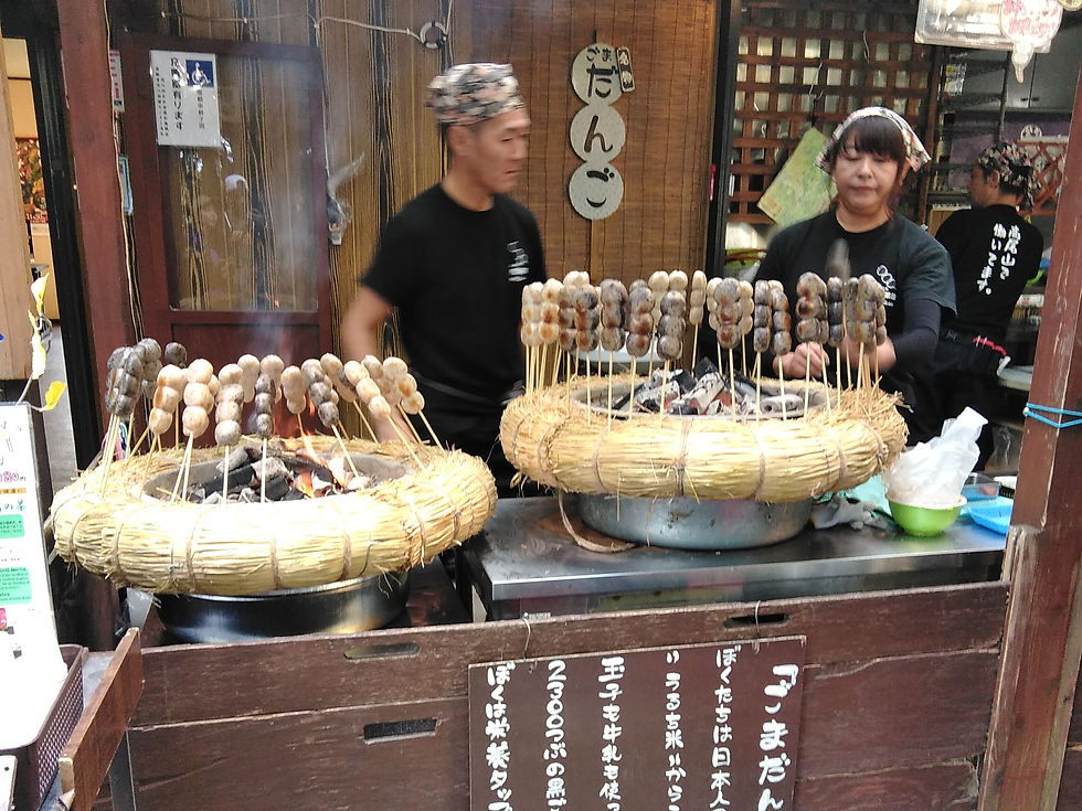
When the trails converged, there was another area where a large number of people gathered. Here there was a dango stand with seating areas. This dango was unique in that they contained black and golden sesame inside the balls. They gave the food a nice savoury-salty flavour that was a nice change from the usual. We stopped by here for a short time to have one of these before continuing on to the top.

Another stretch of hike later, we finally reached the top. There was another large gathering of people here as well. In the centre of the area, there was a pole of some sort that marked the area as the peak of the mountain. People crowded around it to try to take a picture of their accomplishment. Most people being Japanese, they formed a line to take pictures in an orderly fashion. The ladies that I had expected to pass going up the trail were there already, and they hardly looked to have broken a sweat, much to my disappointment. My pride was definitely hurt from their proving my prediction wrong.

After taking a couple of photos of the view and the area, we then headed back down the mountain. This part was probably the most enjoyable part for me, as we took a different trail down. We took trail four down to pass through the suspension bridge, and the trail was more of a hike than trail one. This trail had no concrete and was complete surrounded with trees. The start of the trail also had a warning of the slipping for those going down. The warning made sense, as the beginning of the trail going down was fairly steep. The trail was also quite narrow, with a wall of trees and soil on one side, and a menacing steep drop on the other. The recent typhoon seems to have done a number on the area, and I wondered if the trail had been wider before the event.

There weren't very many landmarks along this trail, and we walked in single file for most of the way. We often stopped to let others pass us so that we could take our time going through the trail. It was some time before we actually reached the bridge, and it was quite a narrow one. I had expected a more aged structure, but the bridge seems to have been reinforced with stronger materials. It was a suspension bridge by all means, but it felt very stable and hardly swung.

The rest of the trail was largely uneventful, but demanded the same level of attention when it came to footing. The only memorable part of the trail after the bridge was a junction with trail two. It had warning tape that said in both English and Japanese that the trail was closed due to the typhoon, but it had been visibly tampered with. This was proven when we watched an elderly lady with two walking sticks blatantly ignore the tape and signs. I simultaneously applauded her gumption and derided her decision quietly.

The trail eventually led back to trail one, and everything became concrete again. We stopped to get a snack from a shop by the gondolas before continuing. I didn't particularly enjoy the downhill trek on trail one, as the steepness was a bit taxing on the balance. The concrete didn't provide the same footholds as the dirt and roots of nature. There were also a lot more people going up the trail at this time.

By the time we reached the base of the mountain, roughly two hours had elapsed. If we were really aiming for time, we probably could have done the whole trek in just over an hour. There were people using the trail as jogging trails as well, it seemed, so it was definitely easy enough to do regularly at a faster pace. Still, we spent a good amount of calories on the hike, so we stopped by one of the soba restaurants here. The soba at the start of the hike is relatively famous amongst the locals, and is one of the attraction points of the mountain. It's a great way to finish the trip to Mount Takao.

That's my experience with Mount Takao. Most that have done the hike wax poetic about the leaves in mid- to late autumn, so a late November hike would probably be ideal if you want to go. Thanks for reading!
If you like hikes and you're planning a visit to Taipei, there's Elephant Mountain. For other stuff to do in Tokyo, why not try the Instagram-famous TeamLAB: Borderless exhibition? Or if you're looking for something to do while you're on the go, you can check out these games.


Comments